Arnab Cyclone Nears Andhra Coast
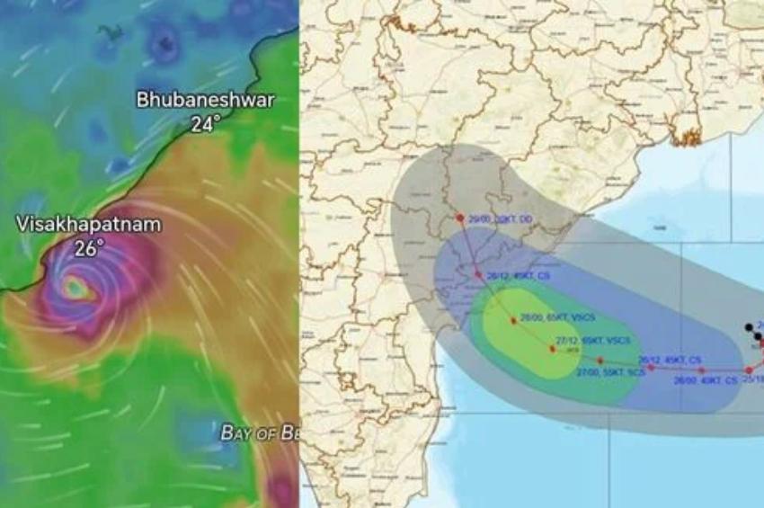
Chennai: The deep depression over the Bay of Bengal is set to intensify into Cyclone Arnab today, with the India Meteorological Department (IMD) warning that the storm could make landfall along the Andhra Pradesh coast on October 28. Wind speeds are expected to reach up to 140 kmph, while several districts in Tamil Nadu are likely to experience heavy to very heavy rainfall over the coming days.
Depression Strengthens Over Bay of Bengal:
According to the Chennai Regional Meteorological Centre, the system that originated as a deep depression over the central-east and adjoining southeast Bay of Bengal intensified into a depression on October 24 before strengthening further into a deep depression.
Weather experts predict the system will gain more strength on October 26 and develop into Cyclone Arnab over the central-east and adjoining central-west Bay of Bengal. By October 27, it is expected to become a severe cyclonic storm as it continues moving northwestward.
Andhra Coast Braces for Landfall:
The cyclone is forecast to intensify further into a very severe cyclonic storm while approaching the Andhra Pradesh coast. It is likely to cross the coastline between Bapatla and Visakhapatnam, including the Yanam region, during the morning hours of October 28.
At the time of landfall, sustained wind speeds of 115 to 125 kmph are expected, with gusts reaching up to 140 kmph, posing a significant threat to coastal infrastructure, transportation, and fishing activities.
Another Weather System Adds to Rainfall Threat:
In addition to Cyclone Arnab, a low-pressure area that had been active over the Lakshadweep region in the southeast Arabian Sea has now shifted towards Kerala. A trough stretches from this low-pressure zone across Kerala to the northern Tamil Nadu coast, enhancing moisture flow across the region.
Meteorologists believe this weather pattern will trigger widespread rainfall over Tamil Nadu during the next 48 hours.
Heavy Rain Alert for Tamil Nadu:
The weather department has issued a heavy to very heavy rainfall warning for:
- Pudukkottai
- Sivaganga
- Ramanathapuram
Heavy rain accompanied by thunderstorms, lightning, and strong winds is also expected in:
- Kanniyakumari
- Tirunelveli
- Thoothukudi
- Tenkasi
- Virudhunagar
- Madurai
- Theni
- Dindigul
- Karur
- Tiruchirappalli
- Thanjavur
- Tiruvarur
- Nagapattinam
Several other districts may witness moderate rainfall through the day.
Rain Likely to Continue:
On October 27, Ramanathapuram district is likely to continue receiving heavy rainfall, while districts along the Western Ghats and other parts of southern Tamil Nadu may experience moderate showers.
Authorities have advised residents in low-lying and flood-prone areas to remain alert as rainfall intensity could increase depending on the cyclone's movement.
Chennai Weather Forecast:
Chennai and its suburban regions are expected to remain under cloudy skies. Isolated areas across the city could receive moderate rain along with thunderstorms and lightning during the day.
Fishermen Warning Issued:
Strong winds are expected over Tamil Nadu's coastal waters, the Gulf of Mannar, and the Comorin Sea region. Wind speeds could range between 35 and 45 kmph, with gusts touching 55 kmph.
Similar conditions are likely to prevail over the north Tamil Nadu coast on October 27 and 28. As a precaution, fishermen have been strongly advised not to venture into the sea until weather conditions improve.
- Deep depression expected to intensify into Cyclone Arnab.
- Andhra Pradesh coast likely to face landfall on October 28.
- Wind gusts may reach 140 kmph.
- Heavy to very heavy rain forecast for southern Tamil Nadu districts.
- Chennai may experience moderate rain and thunderstorms.
- Fishermen advised to avoid sea travel due to rough conditions.